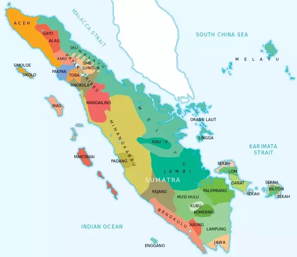
umatera itself consists of hundreds of ethnics, with the most prominent ones are Batak, Melayu, Minang, Palembang, Aceh, and Gayo. The likes of Jambi, Rejang, Mandailing, Mentawai, and Lampung are also dominant enough in few particular territories.
Let’s start in 1945.
Things only get complicated once Indonesia gained independence as juvenile nation back in 1945. The juvenile government decided to partition Indonesia to eight provinces, lumping the whole island of Sumatera into single province that was called, of course, Sumatera.
Provinsi Sumatera is the earliest first-level administrative division in this large island, the capital was in Bukittinggi. However in some ocassions, the capital is often moved to Medan. This is due to the lack of stability in that period.
Besides acting as the capital of Sumatera, Bukittinggi was also prominent for the early republic. The geographical location in the middle of Sumatera was also one reason why this city was chosen as the command center.
The map is not super-accurate, I made it in as quickly as possible to give clearer illustrations about what happened in this island. The Dutch however still didn’t recognize several regions of this province, such as Riau, Bangka Belitung, and South Sumatera as mentioned in Renville Agreement. But to (over)simplify the answer, let’s just ignore those facts.
Move forward to 1948.
In 1948, to ease the administrative controls, the government of Indonesia split Sumatera into three provinces.
- Provinsi Sumatera Utara, capital in Medan
- Provinsi Sumatera Tengah, capital in Bukittinggi
- Provinsi Sumatera Selatan, capital in Palembang (and Curup)
Medan as the largest city in Sumatera controlled North Sumatera, while second largest city in Sumatera, Palembang, controlled South Sumatera. In emergency times, the capital of South Sumatera was moved to Curup for a short period.
The in-between region was still under Bukittinggi’s helm.
(don’t protest, this is hand-drawn, the border cannot be exactly accurate)
What was mildly interesting is that all of three capitals, none of them are located near the beaches contrary to what we see in Sumatera today. This also symbolize three most dominant ethnics in Sumatera : Batak, Minang, and Palembang.
During this time, representatives of Aceh people had requested Soekarno, first president of Indonesia for rights to rule over themselves. Soekarno initially had accepted this proposal in June 1948, however later he did not fulfill his promise and lumping Aceh people together with more-dominant Batak under Sumatera Utara province. This decision made Aceh people feel betrayed and this resulted in several rebellions that was led by Daud Beureueh who later declared Aceh as independent nation.
Realizing this mistake, Soekarno granted the provincial status for Aceh, but this was considered too late. Aceh had revolted against the republic.
One year later in 1949.
The chaos in Sumatera Utara forced Soekarno to split this province into two provinces, the new two provinces are :
- Provinsi Aceh, capital in Kutaraja.
- Provinsi Sumatera Timur & Tapanuli, capital in Sibolga.
It made Sumatera looks a bit odd.
Which is ridiculous because Sumatera Timur (East Sumatera) capital, Sibolga, was actually located on the West coast, replacing Medan. This map is not very accurate because there are few regions that are still claimed by the Dutch but since this one is for explanation purpose, let just (again) ignore that.
But Provinsi Aceh only stayed for one year. The rebellions cannot be tamed by Indonesia and Soekarno decided to had them under Sumatera Utara command once again. Daud Beureueh himself declared Aceh independence in 1953 under Darul Islam leadership of Sekarmadji Maridjan Kartosoewirjo.
During early 1950’s Aceh became so unstable that Indonesia had to declare war against the rebels. It’s only after the Darul Islam movement was defeated, Aceh finally came into peace.
Fast forward to 1957, Aceh is back once again as a province.
The stable Aceh finally get the provincial status it has been wanted for long but unrest are still occasionally happened. Sumatera Tengah on the other hand are split as well into three new provinces, adding Riau and Jambi into equation.
The provinces of Sumatera were :
- Provinsi Aceh, capital in Kutaraja
- Provinsi Sumatera Utara, capital in Medan
- Provinsi Sumatera Barat, capital in Bukittinggi
- Provinsi Riau, capital in Tanjungpinang
- Provinsi Jambi, capital in Jambi
- Provinsi Sumatera Selatan, capital in Palembang
No, the capital of Riau is not located in the middle of ocean. It is located in their most historical town of Tanjungpinang in small Bintan island.
Due to the difficulties managing such large province from small island, capital Tanjungpinang only stayed for two years before finally being moved to another city, which is Pekanbaru, in 1959. Before being declared as capital, Pekanbaru was only a small town. Later this city grew so fast after Americans struck oil in this province of Riau.
Same thing happened to Sumatera Barat. Their capital was moved in 1959 from Bukittinggi to Padang. This is mostly due to Padang is located near the harbor, consisted mostly of flatland, and had much more spaces for development.
So, there were two changes in capital cities in period of 1957–1959.
In 1959, Provinsi Aceh was granted special autonomy status to reduce the unrest that kept happening in this province. It was renamed as Daerah Istimewa Aceh or Aceh Special Region. And later in 1962, the government changed the name of Kutaraja into Banda Aceh.
The population boom in Indonesia caused the needs to split Sumatera into more provinces. In 1964, the southern tip of Sumatera Selatan was separated and this region was made into new province called Lampung, the capital is on two cities adjacent to each other, Tanjungkarang-Telukbetung.
Indonesia suffered from political unrest in 1965 but regained stability soon after with New Order government. Realizing that the West Coast region of Sumatera Selatan as isolated and very underdeveloped, Soeharto, the second president of Indonesia, decided to separate the region west to Bukit Barisan as new province, the 26th Indonesian province, called Bengkulu.
The Bengkulu and Sumatera Selatan borders are drawn along the Bukit Barisan Mountain Range, and Sumatera remained this way until the fall of Soeharto.
Provinces of Sumatera in 1967 are :
- Provinsi Aceh, capital in Banda Aceh
- Provinsi Sumatera Utara, capital in Medan
- Provinsi Sumatera Barat, capital in Padang
- Provinsi Riau, capital in Pekanbaru
- Provinsi Jambi, capital in Jambi
- Provinsi Sumatera Selatan, capital in Palembang
- Provinsi Bengkulu, capital in Bengkulu
- Provinsi Lampung, capital in Tanjungkarang-Telukbetung
And this is the most stable period for Sumatera, no changes from 1967 to 2000.
In 1983, Tanjungkarang and Telukbetung was integrated into one city named Bandar Lampung, that is now thriving on the south.
It was the fall of Great Dictator Soeharto that once again caused few regions to ask for provincial status. The period of post-2000 in Sumatera was symbolized with the formation of two new island provinces. In 2000, Bangka Belitung was then separated from Sumatera Selatan, the capital is in Pangkal Pinang.
Two years later, an all-island province of Riau Islands was separated from Riau mainland, the capital is (once again) in Tanjungpinang.
The underlying reason for both separation was development gap. The people of Bangka Belitung and Riau Islands felt that they were often neglected by regional government and wanted rights to economically manage their own regions.
From 2002 until today (2017), the administrative of Sumatera is as follow :
- Provinsi Aceh, capital in Banda Aceh
- Provinsi Sumatera Utara, capital in Medan
- Provinsi Sumatera Barat, capital in Padang
- Provinsi Riau, capital in Pekanbaru
- Provinsi Kepulauan Riau, capital in Tanjungpinang
- Provinsi Jambi, capital in Jambi
- Provinsi Sumatera Selatan, capital in Palembang
- Provinsi Bengkulu, capital in Bengkulu
- Provinsi Bangka Belitung, capital in Pangkal Pinang
- Provinsi Lampung, capital in Bandar Lampung
And it looks like what we always see on the today’s map.


